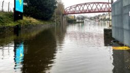
Extreme weather hits the UK, flooding rivers
A swollen river is being searched for a missing person. Police received...
First US winter storm of 2023 brings snow, sleet and tornado threat
Tuesday, the first big winter storm system of the year in the US poured a mixture of snow, sleet, and freezing rain from the Northern Plains to the Upper Great Lakes region while posing a tornado and flood hazard to a significant portion of the South.
The National Weather Service (NWS) predicted severe snowfall of 1 to 3 inches (2-1/2 to 7-1/2 cm) per hour, accompanied at times by thunder, in sections of Nebraska, South Dakota, and Minnesota on Tuesday, with accumulations of more than a foot.
Strong, gusty winds were forecast to cause drifting and blowing snow in some locations, while snow fog, mist, and freezing rain created hazardous driving conditions in others, according to the NWS.
The NWS issued winter storm warnings, ice storm warnings, and winter weather advisories in and around Minneapolis and St. Paul, Minnesota, when freezing rain moved north and was followed by bands of heavy snow.
Richard Bann, a meteorologist with the NWS Weather Prediction Center in Maryland, estimated that by Tuesday evening, the western suburbs of the Twin Cities had received around one-half foot of snow while Minneapolis-St.Paul International Airport had received four inches.
The storm front originated from a low-pressure system churning over Iowa, according to the meteorological service.
The arctic blast was part of a bigger weather system that brought heavy showers, severe thunderstorms, hail, and tornadoes to the lower Mississippi Valley, Gulf Coast, Tennessee Valley, and southern Appalachians by Wednesday.
Watches and warnings for tornadoes and severe thunderstorms were in force across a large portion of Louisiana, Mississippi, Alabama, and Georgia, coupled with flood watches for the region’s southern border.
As of Tuesday night, the NWS had received reports of eight tornadoes and dozens more incidents of severe winds inflicting damage to trees, electrical lines, and residences.
“It’s all part of the same system. The heavy snowfall is occurring on the west to northern side of the storm … and then the rainfall and severe weather is across the south,” NWS meteorologist Allison Santorelli said.
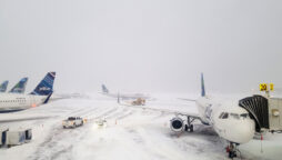
Tuesday saw the cancellation of well over 200 flights at the Minneapolis-St. Paul airport, according to flight tracker FlightAware.
In the meantime, the West Coast was preparing for another “atmospheric river” – a high-altitude circulation of packed moisture – which was forecast to deliver heavy rains and perhaps further flooding to northern and central California beginning Wednesday.
On Wednesday, heavy snowfall was predicted to return to the Sierra Nevada mountains, along with coastal rain and snow at higher elevations in the Pacific Northwest.
Northern California was still recovering from flooding, mudslides, power outages, and road closures caused by a weekend Pacific storm.
Santorelli stated that strong gusts accompanying the new batch of imminent downpours could uproot trees and bring about additional blackouts.
As of early Tuesday morning, more than 21,000 households and businesses in northern California were without power, according to data from poweroutage.us.
Catch all the Business News, Breaking News Event and Latest News Updates on The BOL News
Download The BOL News App to get the Daily News Update & Live News.