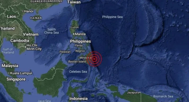
A strong earthquake shook parts of the southern Philippines early Wednesday, according to the United States Geological Survey (USGS).
The quake, initially reported as magnitude 6.7, was later revised to 6.4. It struck at 3:02 a.m. GMT, with its epicenter located approximately 27 kilometers (16.8 miles) east of Santiago in the Cagayan Valley region of northeastern Mindanao. The tremor occurred 58.5 kilometers (36 miles) underground.
The Philippine Institute of Volcanology and Seismology (Phivolcs) said there was no tsunami threat following the quake. While aftershocks and potential damage are expected, no immediate reports of casualties or property damage have been confirmed.
This earthquake follows a series of powerful tremors in the region. In October, Eastern Mindanao experienced two earthquakes measuring 7.4 and 6.7 in magnitude, which resulted in at least eight deaths. Earlier, a 6.9-magnitude quake struck Cebu province, killing 76 people and damaging or destroying approximately 72,000 homes.
The Philippines sits along the Pacific “Ring of Fire,” an area known for intense seismic and volcanic activity that stretches from Japan through Southeast Asia across the Pacific basin, making the country particularly prone to earthquakes.
Earlier in October, Eastern Mindanao was rocked by two earthquakes of magnitude 7.4 and 6.7 that killed at least eight people. Before that, a magnitude 6.9 quake killed 76 people and destroyed or damaged 72,000 houses in Cebu province in central Philippines, as per official figures.