

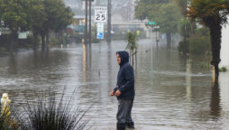
Pacific storm forces mudslides, evacuations in California
Pacific storm dumps torrential rains and powerful winds in southern California. 180,000...

Unpredictable Weather Patterns: El Niño and La Niña switch roles in California
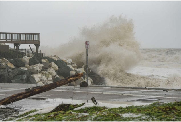
Big waves, snow-capped mountains, and flooded coastal streets are all signs of El Nio in California during a La Nia year, which is typically marked by dry and warm weather.
With global warming emerging as a potential contributor, several earth scientists have been looking for an explanation to explain why the typically opposing-behaving weather events appear to have reversed positions.
According to Jin-Yi Yu, an atmospheric scientist at the University of California, Irvine, climate change may have an impact on how long each occurrence lasts, which in the past 25 years has frequently occurred for back-to-back years. That might then have an impact on how they manipulate the weather.
Yu stated through email that the study community has seen that El Nio and La Nia events have seemed to last longer on average in the twenty-first century, which may be related to global warming.
La Nia, which is characterised by lower-than-average sea surface temperatures in the equatorial Pacific, is in its third year running, but federal researchers think the phenomenon is coming to an end and that the Eastern Pacific will see a “neutral” midwinter and spring.
Warmer-than-average sea surface temperatures in the equatorial Pacific are indicative of an el nino, and they support tropically supercharged atmospheric rivers that bring significant precipitation to California, as has been the case since Sunday.
Yu, who has been observing the phenomenon for several years, recorded the erosion of the traditional effects of El Niño since its exceptional occurrence in 1997, during which snowfall was reported in urban areas of Southern California and the waves were considered historic.
According to Yu, a National Science Foundation-funded researcher, the recent weather pattern in Southern California is not consistent with what is typically expected during a La Niña year. It is more similar to the type of winter rainfall pattern that would be seen during an El Niño year.
He suggests that this may be due to the North Pacific marine heat wave, which causes above-normal sea surface temperatures for extended periods of time, altering the path of winter storms and bringing more rainfall to Southern California. However, it’s also a possibility that La Niña will still show its traditional form later.
As noted by National Weather Service meteorologist Ryan Kittell, while downtown Los Angeles has received nearly 9 inches of rain since October 1, if the rain stops before the end of September, which it did last year, it will be below the average of 14 inches for a typical season.
Catch all the US News, Weather News, World News, Breaking News Event and Latest News Updates on The BOL News
Download The BOL News App to get the Daily News Update & Follow us on Google News.