


The ‘Pineapple Express’ winter storm devastates California
Joe Biden pledged immediate federal help in response. This is the state's...

Late-season winter storms threaten California, Northeast
California, already reeling from a month-long spate of late-winter storms, braced for another round of heavy rain, wind, and snow on Monday, while most of New York state and New England braced for a severe Nor’easter.
The latest Pacific storm slammed into northern California and was forecast to intensify late Monday night into Tuesday as it moved across central and southern portions of the state that were still flooded over the weekend.
Emergency teams are prepared for the season’s 11th “atmospheric river,” an airborne current filled with copious tropical moisture from the ocean, by resuming sand-bagging operations and patrolling levees and rain-swollen riverbanks around the clock.
According to the Federal Emergency Management Agency, mandatory evacuation orders remained in effect for residents in ten California counties.
The National Weather Service (NWS) issued flood watches for parts of the state, as well as warnings for gale-force winds and widespread tree uprooting.
“With the ground already saturated from the previous storm and river levels well above average, another round of major and life-threatening flooding is likely” along California’s coast, the Sierra Nevada foothills, and the state’s vast Central Valley farm region, the NWS said.
Some of the greatest rain, up to 10 inches (25 cm), might fall in the Southern California mountains of Santa Barbara and San Bernardino, state climatologist Michael Anderson told reporters on Monday.
The rain was expected to expedite the melting of snow left on the ground by previous blizzards in mid-level mountain areas, contributing to significant flow and flooding.
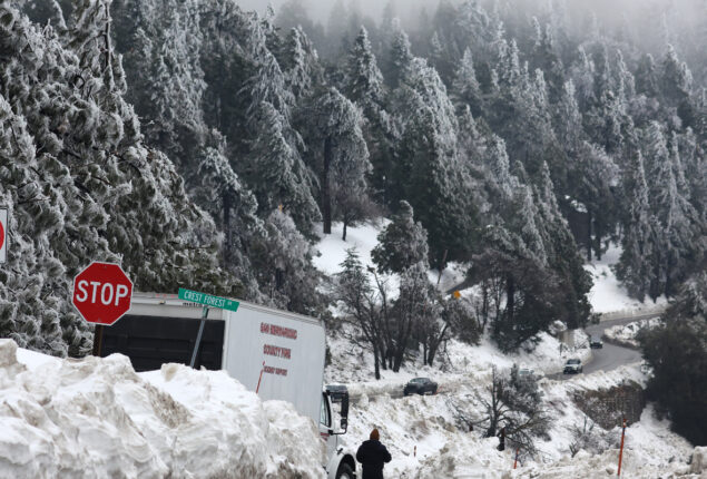
But, the latest storm was forecast to dump another 3 to 5 feet (1-1.5 meters) of snow at higher elevations in the Sierra range, exceeding 8,000 feet (2,400 meters), according to the NWS.
Anderson anticipated that more precipitation from the approaching storm, as well as one or two more still brewing in the Pacific, would certainly drive the southern Sierra snowpack to all-time highs, breaking the 1969 record.
From late December to mid-January, nine atmospheric rivers pummelled California in fast succession, causing catastrophic flooding, levee breaches, mudslides, and pounding waves. At least twenty persons were killed.
On Thursday and Friday, the 10th atmospheric river system of the season struck, causing rivers and creeks to overflow their banks in various low-lying places, most notably along central California’s coast.
Drone footage from above Monterey County showed entire neighborhoods submerged by dirty, brown waters as the Pajaro River levee burst. Evacuation alerts and orders remained in effect for the county’s 430,000 population on Monday.
One evacuee from the flood-ravaged town of Pajaro, farm worker Pedro Rangel, 42, sought to return home on Monday but was unable to do so due to the muck and water around his home.
“It’s sad for all of the people who live there. You lose everything,” Rangel told at an evacuation center in nearby Watsonville.
Some 225 kilometers to the south, public works crews in San Luis Obispo County were monitoring stream levels and using sandbags to reinforce a rain-weakened earthen levee along the Arroyo Grande Creek in the hopes of preventing new floods.
“Now the creek levels are so high that it’s really not going to take a lot to cause flooding,” said Rachel Monte Dion, the county’s emergency services coordinator.
A Nor’easter storm was expected to drop up to 16 inches of heavy snow and whip gusts of up to 72 km from Pennsylvania and New York state up into Maine beginning Monday night and lasting through Wednesday, according to the National Weather Service.
Heavy, wet snow from the storm was likely to topple trees and power lines, causing power outages, while also diminishing visibility and making road travel extremely dangerous, forecasters said.
Catch all the US News, World News, Breaking News Event and Latest News Updates on The BOL News
Download The BOL News App to get the Daily News Update & Follow us on Google News.